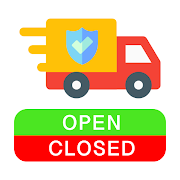
Find the Safe Havens App in the Google Play Store (Maps & Navigation).
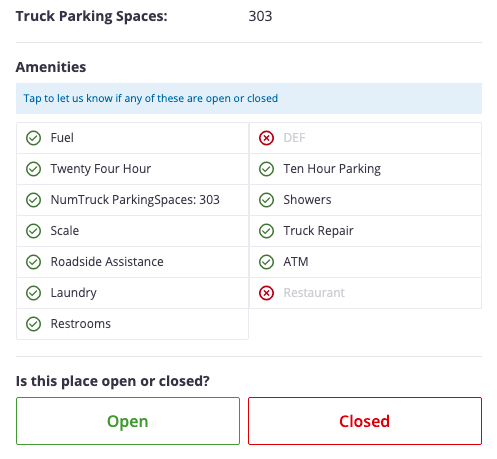
Truck drivers and Road Trippers – Access and report on up to date amenity information for gas stations and truck stops. Find out if your next rest area will have what you need. Crowdsourced amenity information includes: ATMS, Fuel, Restaurants, Bathrooms, Showers, Laundry, Parking Hours and More
There were over 3.5 million people working as truck drivers in the United States in 2019. For days or weeks at a time these truck drivers take to the roads to transport goods and materials across the Nation. Servicing those 3.5 million workers are dispersed truck stops with showers, bathrooms, and locations to park where tired drivers get their essentials and required rest. In March, the COVID-19 outbreak hit the US and a National Emergency was declared. Truck Drivers perform a critical role in our economy and especially during this crisis. In the midst of a global pandemic, there is great uncertainty and continually evolving change. Businesses have been required to instate social distancing policies and close their doors. Consequently, truck drivers face additional unpredictability of what lies on the road ahead.
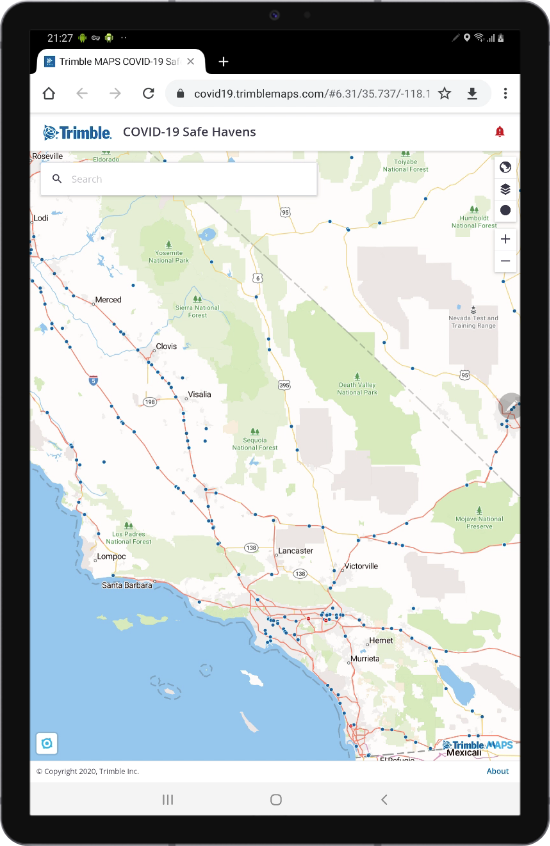
Our innovative friends at Trimble MAPS quickly implemented a call to action to support the transportation community by leveraging their map layering technology and launching Trimble MAPS COVID-19 Safe Havens, a free web app to help truck drivers find available amenities across their routes. In collaboration and with the support of Trimble MAPS, the Treeline team created the COVID-19 Safe Havens native android application. The At Startup Speed blog is a dedicated space to talk about innovation and bring this community together. Trimble MAPS is an amazing transportation development platform that Treeline is excited to work alongside, so we are pleased to share more about the COVID-19 Safe Havens App here atstartupspeed.
“Partnering with other organizations who feel as strongly as we do to support professional drivers is hugely important to us,” said Rishi Mehra, executive, Trimble MAPS. “Expanding the reach of our COVID-19 Safe Haven website through Treeline’s native Android app version helps achieve our goal to spread awareness on which truck stops and rest areas are open and which conveniences, like showers and parking, are available for drivers.”
Can you give me some background on what Trimble MAPS is and what it historically has been used for?
Trimble MAPS provides global map-centric technology dedicated to transforming journeys through innovative routing, scheduling, visualization and navigation solutions. Built on map data and a routing engine designed specifically for commercial vehicles, its development platform and trusted products are made for a broad range of industries, workforces and fleets of all sizes. The Trimble MAPS brands including PC*MILER, CoPilot and Appian are the foundation for safe and efficient journeys worldwide—one driver, one vehicle, one fleet at a time.
Could you share a little about how the COVID-19 Safe Havens idea developed and the process to get the web app launched?
At Trimble MAPS, we wanted to do our part to help the transportation community, especially professional drivers, starting with an essential feature of the truckers’ life—the truck stop. While these centers may not be “essential” for individuals, they certainly are for professional drivers who rely on the parking lots of those travel centers as places where they can safely pull over to sleep, eat, and use the bathrooms and showers. The situation is constantly changing on the ground and complicating journeys. Now more than ever, drivers need technology that supports them along the way. What truck stops and rest areas are open? Are restaurants open and showers available? Where can drivers find safe, reliable parking? Drivers need the answers to these questions to complete their jobs in this “new normal.”
Why did Treeline decide to get involved with Safe Havens?
Treeline has done a few different things to try and help our community get through the pandemic. We created a community COVID tracking dashboard for San Diego, but also wanted to build something that served (what we felt) was a partially underserved group of essential workers. When we saw what the Trimble Maps team had built we thought it would be a great point of collaboration that leveraged some of our skill sets in mobile development.
How does the application serve the transportation community during the COVID pandemic?
If you’re a truck driver (or most anyone traveling right now), the problem is accurate information about what is available to you on the road. Each state has its own closures and protocols for safe social distancing that can make travel extremely difficult. This app provides that vital information about what IS available for the drivers keeping this economy running. The app provides a crowdsourced solution that can help keep our essential drivers safe and taken care of.
What did the team have to do on the technical side to make things work?
We started off with gathering requirements and looking over exactly what the web application did, we essentially had to extract out that functionality and rebuild it to serve a native android experience. We integrated extensively with their backend that provides these map layers. They have an easy to use API that we’re interacting with in order to load these different amenities in the real-time locations as they’re updated. Each one of those updates and features on the web have some sort of interaction with their infrastructure, which was being done through these API calls. We were lucky to have support from some of the exceptional team members at Trimble Maps who were available whenever we had questions.
“Communication is key with any collaboration, ” said Zach Januik, Product Manager, Trimble MAPS. “The Treeline development team was very hands on, proactive and very easy to work with. Together, we were able to not only complete the goal of releasing an app, but the partnership helped Trimble MAPS improve the original web app as well.”
Why did you choose to develop specifically for Android
We wanted this application to be available for lots of different drivers and the predominant device across many fleets is an android device. We also wanted to build natively so that as we update over time we could leverage all the device’s hardware that native development affords.
Are there future plans for the product?
I’d say that first and foremost is making sure that we can continue to give drivers access to as much valuable information about their travel and safety as possible. Expanding our list of resources and measuring usage to optimize ease of use. Then as this pandemic evolves, thinking about how we can adjust the application to continue to serve the drivers keeping our shelves stocked and cars running. As time progresses there may be fewer unknowns, but potentially this application could help with contact tracing and information, maybe even amenity layouts with information about outdoor seating and other regulation perhaps required for entry.
The future continues to hold uncertainties but we know we will get through these challenging times. We want to sign off with a reminder of the valuable work truck drivers do, and express our gratitude to them. Without our nation’s truck drivers we would not have the essentials needed to survive this pandemic.
Thank You!